ENC vs RNC: Vector and Raster Charts Explained
The two electronic charts can look alike but behave nothing alike. What separates an ENC from an RNC, and why the difference decides what your ECDIS can actually do.
On screen, the two can look almost the same. The difference is everything the machine underneath cannot see.
An ENC and an RNC are both official electronic charts, and both will show you a coastline, a buoy, and a sounding. But one is a structured database the ECDIS can reason about, and the other is a flat picture it can only display. That distinction shapes what your equipment can do for you, what the rules will accept, and where electronic charting is heading.
At a Glance
Two Kinds of Electronic Chart
An ENC (Electronic Navigational Chart) is official vector data. Every feature, a depth contour, a buoy, a wreck, a coastline, is stored as a discrete object with its own attributes, built and issued under the authority of a national hydrographic office.
An RNC (Raster Navigational Chart) is an official raster image: a georeferenced digital scan of a paper chart, made of pixels. It carries the same information a paper chart would, because it is a paper chart, photographed.
The word “official” matters in both cases. It means the data was produced under government hydrographic authority, which is what separates an ENC or RNC from the many private, unofficial electronic charts that may look similar but carry no such standing.
Vector vs Raster: What Is Actually Different
The gap between them is not how they look but what they are made of, and it is best seen side by side.
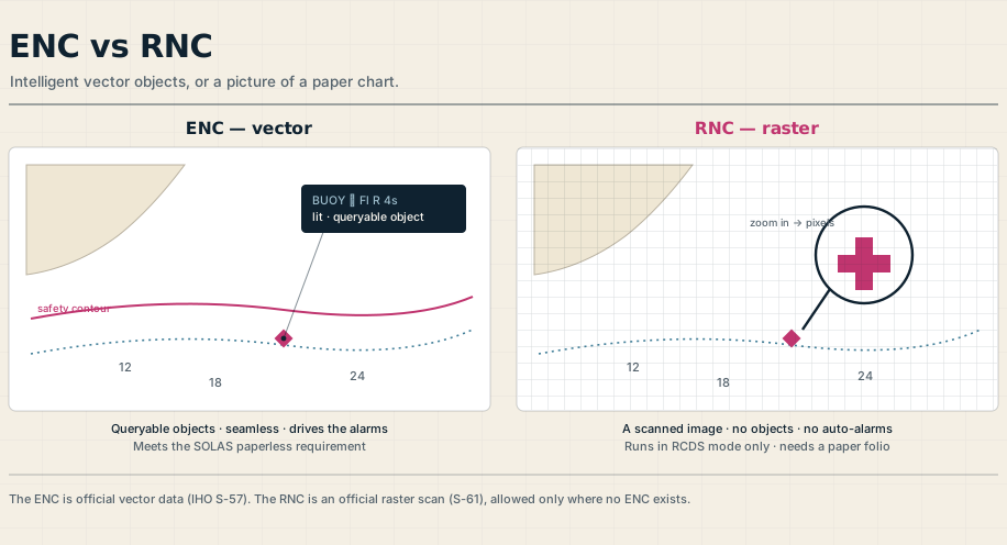
Because an ENC is a set of objects, the system knows that a particular symbol is a buoy and another is a wreck. You can click a feature for a full report of its attributes, turn whole categories of information on or off to cut clutter, and zoom in without the picture breaking up, while the text always stays upright and the palette shifts cleanly between day, dusk, and night. ENC data is also seamless: there are no chart boundaries to cross.
A raster chart knows none of this. To the computer, the pixels that draw a buoy are no different from the pixels that draw a submerged wreck, because there are no underlying objects at all, only colored dots. Zoom in past the chart’s own scale and the image simply pixelates, the text can sit sideways, the palette is limited, and each chart remains a separate sheet with edges, exactly like the paper portfolio it came from.
Why the ENC Can Keep You Off the Ground
This is where the difference stops being academic. Because the ENC stores depths and dangers as data, an ECDIS can actively watch the water ahead, comparing your safety contour and safety depth against the route and sounding the anti-grounding and look-ahead alarms when something threatens.
A raster chart cannot drive any of that. RNC data, being only an image, will not trigger those automatic safety alarms, so a system running in raster mode loses most of the protection that makes an ECDIS more than a moving-map display. The ENC even carries a quality indicator, the category of zone of confidence, or CATZOC, telling you how much to trust the survey behind the depths, information a scanned image has no way to hold.
The Standards Under the Hood
A little of the plumbing explains why ENCs behave so consistently. The data itself follows the IHO S-57 standard, the presentation, every symbol, line, and color, follows S-52 so the chart looks the same on any approved ECDIS, and the data is protected in transit by encryption under S-63.
Raster charts follow a separate standard, S-61, and are shown through a Raster Chart Display System. You do not need to memorize the numbers, but it helps to know that the ENC’s consistency and intelligence are designed in, not incidental.
The Rules: What Counts for Chart Carriage
Under SOLAS, a ship must carry adequate, up-to-date charts, and an approved ECDIS using official ENCs is accepted in place of paper, provided a proper backup arrangement is in place, typically a second, independent ECDIS.
Raster is treated very differently. An ECDIS may run in raster mode using RNCs only where ENC coverage does not yet exist, only with flag-state approval, and only when used together with an appropriate folio of up-to-date paper charts. In other words, an RNC is a recognized stopgap, not a route to paperless navigation, and it always leans on paper behind it.
The Direction of Travel
Raster is fading. The United States completed the retirement of all its traditional paper and raster charts by January 2025, leaving the ENC as the only chart product its hydrographic office now issues, and other authorities are moving the same way as ENC coverage approaches the global and is reschemed into cleaner, larger-scale cells.
The next step is already arriving. A new generation of standards, the IHO S-100 framework and its S-101 chart specification, is set to succeed S-57, carrying richer data and letting the chart act as a base layer for live overlays such as tides and currents. The practical takeaway for a watchkeeper is simple: learn the ENC deeply, because it is the present and the future, and treat raster as the backup it has become.
Frequently Asked Questions
These are the questions officers and cadets ask most about ENCs and RNCs, from how they differ to whether raster charts are still allowed. Here are the short answers.
What is the difference between an ENC and an RNC?
An ENC is official vector data, where every feature is a discrete object the ECDIS can query and act on. An RNC is an official raster image, a georeferenced scan of a paper chart made of pixels, with no underlying object data. The ENC is intelligent and seamless; the RNC is essentially a picture.
Can you use RNCs instead of ENCs on an ECDIS?
Only in limited circumstances. An ECDIS may run in Raster Chart Display System mode using RNCs where no ENC coverage exists, subject to flag-state approval, and it must then be used alongside an appropriate folio of up-to-date paper charts. Where an ENC is available, it should always be used.
Do you still need paper charts with ECDIS?
It depends on the mode. An approved ECDIS using official ENCs can replace paper if a proper backup arrangement, usually a second independent ECDIS, is in place. But when running on raster charts in RCDS mode, a folio of up-to-date paper charts is required.
What is the difference between S-57 and S-101?
S-57 is the current IHO data standard behind today’s ENCs. S-101 is its successor within the new S-100 family, an object-oriented model that carries richer data and supports interoperable overlays such as tides and currents. Hydrographic offices are producing S-101 charts as the transition rolls out.
Are raster charts being phased out?
Increasingly, yes. The United States completed the retirement of its raster and traditional paper charts by January 2025, making the ENC its sole chart product, and other authorities are trending the same way as ENC coverage and standards mature. Raster remains useful only as a backup where vector data is unavailable.