Position Fixing Methods: How a Ship Knows Where It Is
A fix is only as good as the method that confirms it. The ways a ship fixes its position, from visual bearings to GNSS and the stars, and why you never trust one alone.
Knowing where you are sounds like the simplest thing in navigation, and on a clear day with a working satellite receiver, it is. The skill lies in not trusting any single answer, because a fix is only ever as good as the second, independent method that confirms it.
Every method below produces the same basic thing, a position line, and the art is in crossing enough of them, from enough different sources, that you can believe the result.
What a Fix Actually Is
The building block of every fix is the position line: a line drawn on the chart somewhere along which the ship must lie. A single compass bearing of a charted object gives one, so does a radar range, a transit, a sounding, or a star sight. One position line alone tells you only that you are somewhere on that line.
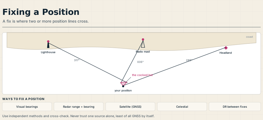
A fix is where two or more position lines cross. Two lines will do, but three is the standard, because three reveals its own errors: the lines rarely meet at a single point, and the small triangle they form is the cocked hat. A tight cocked hat means a good fix, a large one means something is wrong, and prudence says to take the corner nearest the danger as your position. The position lines should also cross at good angles, ideally near ninety degrees, since lines meeting at a narrow angle give a fix that smears along their length.
Visual Fixes: Bearings, Transits, and Ranges
The oldest method is still among the best in coastal waters. Take compass bearings of two or three well-charted objects, a lighthouse, a headland, a conspicuous tower, and plot them as position lines: where they cross is your fix.
Some visual position lines are exceptionally reliable. A transit, where two charted objects come exactly into line, gives a position line with no instrument error at all, more accurate than any compass bearing. A single object can also yield a fix when you combine its bearing with a radar range, or its bearing taken twice with the ship’s run between to give a running fix, and distance off can be had from the vertical sextant angle of a charted height or from a light as it rises or dips below the horizon.
Radar Fixes
In poor visibility, radar comes into its own. A fix can be built from the range and bearing of a single charted object, but the most accurate radar fix comes from the ranges of two or three objects, because a radar measures distance far more precisely than it measures bearing.
For that reason a good navigator leans on radar ranges and treats radar bearings with more caution. Used well, radar gives a dependable fix when the coast is invisible, and it cross-checks beautifully against the electronic position.
Satellite Fixes: GNSS and Its Weakness
For most of the time, the position on the screen comes from a global navigation satellite system, GPS being the best known alongside GLONASS, Galileo, and BeiDou. It is continuous, accurate to a few meters, and effortless, which is exactly what makes it dangerous.
A satellite fix is only as trustworthy as the signal behind it, and that signal can be jammed, spoofed, or simply lost, sometimes without any obvious warning on the display. Treating GNSS as the single source of truth is the modern grounding waiting to happen, which is why it must always be checked against an independent method rather than believed on its own.
Celestial Fixes: The Independent Backup
When every electronic aid fails, the sky still works. A celestial fix is built from sextant altitudes of the sun, moon, planets, or stars, each reduced to a position line, and crossed in exactly the same way as visual bearings.
Celestial navigation is slower and demands practice, but it depends on nothing that can be switched off, jammed, or spoofed. That independence is precisely its value: it is the one fix that no failure of the ship’s systems or shore infrastructure can take away, and the reason the skill is still taught and still worth keeping sharp.
Dead Reckoning: The Thread Between Fixes
Between fixes, the ship’s position is carried forward by dead reckoning, the running estimate from the last known position using course steered and distance run. Corrected for the set and drift of current and for leeway from the wind, it becomes an estimated position.
Dead reckoning is not a fix, but it is the thread that ties them together, and a fix that disagrees wildly with the DR is a warning to check before you believe it. A good navigator always knows roughly where the ship should be, so that a wrong fix announces itself instead of being accepted.
The Discipline: Cross-Check Everything
Pull all of this together and the real method is not any one technique but the habit of comparison. The electronic fix is confirmed by a radar range, a visual bearing, a sounding under the keel, or simple agreement with the dead reckoning, so that no single failure can put the ship somewhere it is not.
How often you fix depends on the water: every few seconds of attention in a narrow channel, far less on an open ocean. But the principle never changes across the whole passage plan: use independent sources, cross-check them against each other, and trust the agreement rather than any one instrument. Position fixing, done properly, is less about finding the ship than about refusing to be fooled about where it is.
Frequently Asked Questions
These are the questions officers and cadets ask most about position fixing, from what a fix is to why GNSS alone is not enough. Here are the short answers.
What is a position fix in navigation?
A fix is the ship’s position found where two or more position lines cross. A position line is any line the ship must lie on, such as a compass bearing, a radar range, or a star sight, and crossing two or more of them pins down the location. Three is the standard, because the small triangle they form, the cocked hat, reveals the quality of the fix.
What are the main methods of fixing a position?
Visual bearings and transits of charted objects, radar ranges and bearings, satellite systems such as GPS and the other GNSS constellations, and celestial sights of the sun and stars. Dead reckoning carries the position between fixes. Each produces position lines that are crossed to give a fix.
What is a cocked hat?
It is the small triangle formed when three position lines do not meet at exactly one point. A tight cocked hat indicates a good fix, a large one indicates an error somewhere, and the prudent navigator takes the corner of the triangle nearest to danger as the ship’s position.
Why can’t you rely on GPS alone?
Because the satellite signal can be jammed, spoofed, or lost, sometimes without obvious warning, and a single corrupted source then puts the ship somewhere it is not. GNSS is accurate and convenient, but it must be cross-checked against an independent method such as radar, visual bearings, or soundings.
Is celestial navigation still used?
Yes, as an independent backup. It is slower than electronic methods and needs practice, but it relies on nothing that can be switched off or interfered with, which makes it the ultimate fallback when satellite and shore systems fail. For that reason it remains part of a deck officer’s training.