Dead Reckoning vs GPS
They are not rivals. GPS gives where the ship is; dead reckoning gives where she should be. How the fix, DR, and estimated position fit, and why both still run today.
Put the question as a versus and you have already misread it. Dead reckoning and GPS are not rivals fighting for the navigator’s trust, and the modern bridge does not choose between them. It runs both at once, because each answers a different question.
GPS tells you where the ship is, to within a few meters, right now. Dead reckoning tells you where the ship should be, and therefore where she is going, from nothing more than her last known position and her own motion.
The skill that keeps a ship off the rocks is not picking the better of the two; it is holding both pictures in your head at the same time, so that the moment they stop agreeing you know something is wrong before the ground tells you.
What Dead Reckoning Actually Gives You
Dead reckoning (DR) is the running calculation of position from a known starting point, the course steered, and the distance run, which is simply speed through the water multiplied by time. From a fix, you lay off the heading and the distance, and the point you reach is the DR position: where the ship would be if she went exactly where she was pointed at exactly the speed her log showed, through water that was not moving. It needs no signal, no satellite, no power. A chart, a pencil, a compass, a clock, and a way of knowing speed are enough, which is precisely why it has outlived every technology meant to replace it.
Its honesty is also its limit. A DR position deliberately ignores the things that push a ship off her intended track, because it cannot measure them: the set and drift of current and tide, the leeway the wind presses on her hull, the small persistent errors of steering and log. So the DR is not where the ship is. It is where she would be in a perfect world, and the sea is not a perfect world. (The name, often said to come from “deduced reckoning,” more likely uses “dead” in the old sense of absolute or exact, as in dead ahead; the derivation is disputed, but the method is not.)
The Concept Most Guides Skip: Estimated Position
The step that turns dead reckoning from a rough guess into real navigation is the one beginners are never taught clearly. Take the DR position and correct it for the set and drift you estimate the current and tide are producing, and for the leeway the wind is causing, and you get the estimated position, or EP: your best judgment of where the ship actually is between fixes. The DR is mechanical; the EP is where seamanship enters, because estimating set and drift well is a matter of knowing your waters, your ship, and the conditions.
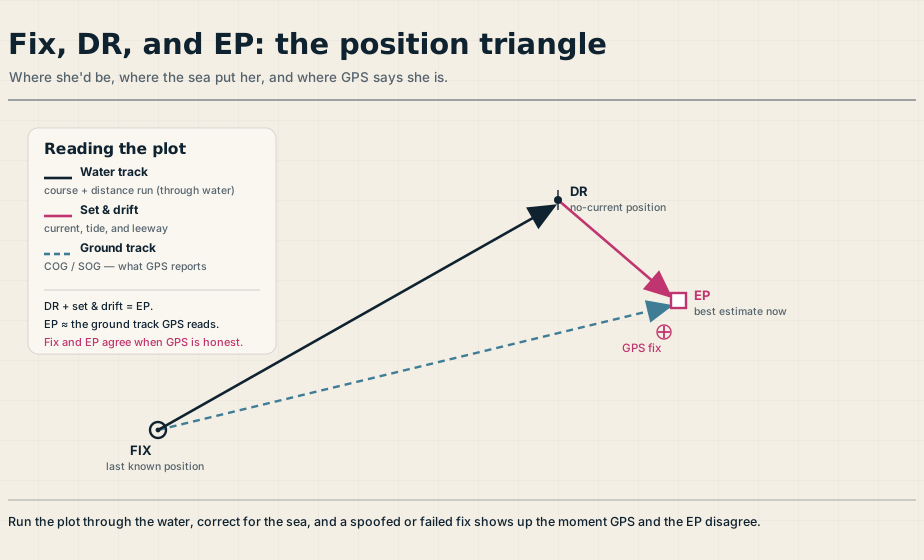
The picture is a simple triangle, and it is worth carrying in your head. The water track, course steered and distance run, runs from the fix to the DR position. The set and drift vector runs from the DR position to the EP. And the line straight from the fix to the EP is the ground track, the course and speed made good over the seabed. That last line is exactly what a GPS gives you directly as course and speed over the ground.
So dead reckoning through the water, plus the sea’s set and drift, equals the EP, which is the very thing GPS reads off in an instant. The two methods are describing the same triangle from opposite corners.
What GPS Actually Gives You, and How
GPS, the original satellite system and still the common name for what is now a family of them, fixes position by ranging on satellites. Each satellite broadcasts its position and a precisely timed signal; the receiver measures how long each signal took to arrive, converts that to a distance, and finds the one point on Earth consistent with the distances to several satellites at once. The technique is trilateration, solving from measured distances, and not, as it is often loosely described, triangulation, which works from angles. With four or more satellites in view a receiver fixes latitude, longitude, course over ground, and speed over ground continuously, typically to within a few meters, and to a meter or better where an augmentation system such as SBAS or differential GPS is available.
That precision is genuinely transformative, and pretending otherwise would be nostalgia. GPS removes the workload of constant manual fixing, drives the position on ECDIS and the radar, and gives the continuous, accurate picture that makes close-quarters and coastal work safer than it has ever been. Modern receivers also track more than one constellation, GPS alongside Galileo, GLONASS, and BeiDou, which improves both accuracy and availability. The case for GPS is overwhelming, and no working navigator would give it up. The case for keeping dead reckoning alongside it is about what happens when GPS is wrong.
When the Satellites Lie: Jamming and Spoofing
GPS fails in two very different ways, and the second is the dangerous one. Jamming floods the GPS frequencies with noise that overpowers the faint satellite signals, so the receiver simply loses its fix: the screen goes blank or flags a loss, and at least you know you have a problem. Spoofing is worse, because the receiver transmits a plausible but false position; the display still shows a confident fix, just not where you are. A jammed GPS tells you nothing. A spoofed GPS tells you a lie with a straight face.
This is no longer a theoretical worry. GNSS interference has become a routine feature of several busy sea areas, including the Baltic, the Black Sea, the Eastern Mediterranean, the Red Sea, and the Arabian Gulf.
In April 2024, falsified signals in the Eastern Mediterranean made 117 ships appear simultaneously at Beirut Airport, and by June 2025 more than 3,000 vessels were disrupted in the Persian Gulf and Strait of Hormuz within a fortnight. The containership MSC Antonia grounded in the Red Sea in May 2025 in an incident widely attributed to GPS jamming, with the reported position changing repeatedly during the event.
In response, maritime authorities have advised ships not to rely solely on electronic navigation and to cross-check position by traditional, non-electronic means. The defense they are describing is the one this whole article is about: an independent dead-reckoning plot, backed by radar and visual fixes, that does not depend on a satellite to be right.
How the Two Work Together on a Real Bridge
The strongest practice is simple to state. Use GPS as the primary source of position, and keep a continuous dead-reckoning and estimated-position plot running alongside it as an independent check. The point of the DR is not to replace the GPS while it is healthy; it is to be the thing the GPS is measured against. When a fix and the EP agree, confidence is high. When they diverge, the navigator has caught something, and the next move is to find out what: an unexpected current, a steering error, or a GPS that has been jammed or spoofed.
There is an elegant by-product of running both. The difference between the ship’s track through the water, which the DR gives, and her track over the ground, which GPS gives as course and speed over ground, is the set and drift she is actually experiencing. The two systems together do not just cross-check each other; they measure the current. This is the layered habit that good passage planning builds in, and it rests on the ordinary seamanship of keeping the plot up to date even when the screen is telling you that you need not bother.
When GPS Goes Dark
Because the DR plot has been running all along, losing GPS becomes a manageable event rather than an emergency. The ship carries on from the last good fix on dead reckoning, and the navigator rebuilds confidence with whatever independent fixes the situation allows: radar ranges and bearings off charted features, visual bearings and transits inshore, a check of the echo sounder against charted depths, and celestial observations offshore where nothing else is in reach.
ECDIS itself can be told to run in a dead-reckoning mode, advancing the position from course and speed when it has no fix to work from. None of this is exotic; it is the core of the trade, and a navigator with a solid DR plot can hold situational control for hours without a single satellite.
That is the real answer to “dead reckoning vs GPS.” One gives precision and the other gives independence, and a ship needs both. The satellites do the heavy lifting on a good day; the plot in pencil is what saves the ship on a bad one.
Frequently Asked Questions
These are the questions cadets and watchkeepers ask most about dead reckoning and GPS, from how each one works to which to trust. Here are the short answers.
What is the difference between dead reckoning and an estimated position?
Dead reckoning gives the DR position from your last fix, the course steered, and the distance run through the water, ignoring outside forces. The estimated position, or EP, is that DR position corrected for the set and drift of current and tide and for leeway from the wind. The DR is where the ship would be in still water; the EP is your best estimate of where she actually is.
Does GPS use triangulation?
No. GPS uses trilateration, which finds position from measured distances to several satellites, not triangulation, which works from angles. The receiver times the signals from four or more satellites, converts each to a distance, and solves for the single point consistent with all of them.
Why do navigators still use dead reckoning if GPS is so accurate?
Because GPS can fail or be deceived, and dead reckoning cannot. A continuous DR plot is the independent check that catches a jammed or spoofed fix the moment it disagrees, and it lets the ship carry on safely when the satellites are lost. GPS gives precision; dead reckoning gives independence, and a ship needs both.
What is the difference between GPS jamming and spoofing?
Jamming overpowers the satellite signals so the receiver loses its fix entirely, which at least makes the failure obvious. Spoofing transmits false signals that make the receiver display a confident but wrong position. Spoofing is the more dangerous because the navigation looks normal while being untrue, which is why an independent cross-check matters.
What should you do if GPS fails at sea?
Carry on from the running dead-reckoning plot and rebuild your position with independent fixes: radar ranges and bearings off charted features, visual bearings and transits, the echo sounder checked against charted depths, and celestial observations offshore. Reduce to a safe speed, keep a sharp lookout, and treat the DR as your backbone until a reliable fix is restored.