The chart on an ECDIS screen looks like a single thing, but it is held together by an alphabet of standards working quietly behind it: S-57, S-52, S-63, and, increasingly, S-100 and S-101. Each number does a different job.
Knowing which standard does what is not trivia. It explains why your chart looks the way it does, why it can be trusted, and why the picture on the screen is about to change in the biggest shift since paper charts gave way to electronic ones.
At a Glance
Why One Chart Needs Several Standards
An ENC is not one file doing everything. Something has to define how the hydrographic data is encoded, something else has to govern how it is drawn on screen, and a third thing has to keep it secure and prove it came from an official source.
The IHO, the International Hydrographic Organization, publishes those standards so that every approved ECDIS reads, displays, and protects chart data the same way. Today, three of them sit behind the chart you use at sea.
The Three Standards Behind Today’s ENC
These are the workhorses, in service since the 1990s and still running on every ECDIS afloat. Each handles one part of turning survey data into a trustworthy chart.
S-57: The Data Format
S-57 is the IHO transfer standard for digital hydrographic data, the format an ENC is actually encoded in. It defines how a hydrographic office builds the vector chart, every depth area, contour, buoy, and coastline, as structured data that an ECDIS can read and interrogate.
Its great strength is also its limit. S-57 was adopted in 1992 and has been frozen at edition 3.1 since November 2000, deliberately held static to give the industry stability, which is exactly why it cannot evolve to carry the richer data that modern navigation now wants.
S-52: The Display Rules
S-52 governs presentation: the symbols, line styles, colors, and display logic an ECDIS uses to draw the data. It is the reason a buoy, a safety contour, or a wreck looks the same on every approved make and model, and why the chart shifts cleanly between day, dusk, and night palettes.
Without S-52, the same ENC could appear differently from one bridge to the next. With it, what you learn to read on one system carries over to the next.
S-63: The Protection Scheme
S-63 is the IHO data protection scheme, the encryption and security layer around ENC distribution. It does three things: it protects the data from piracy, it controls selective access so a ship sees only the cells it is licensed for, and it authenticates the data so the mariner can be sure it came from an official source and has not been tampered with.
This is what lets you trust the chart. An ENC that passes S-63 checks is genuine, current to its issue, and intended for your ship.
S-100: A Framework, Not a Format
The future is not another single chart format. S-100 is the IHO’s Universal Hydrographic Data Model, a whole framework built on modern geospatial standards, designed to free chart data from the constraints S-57 was frozen into.
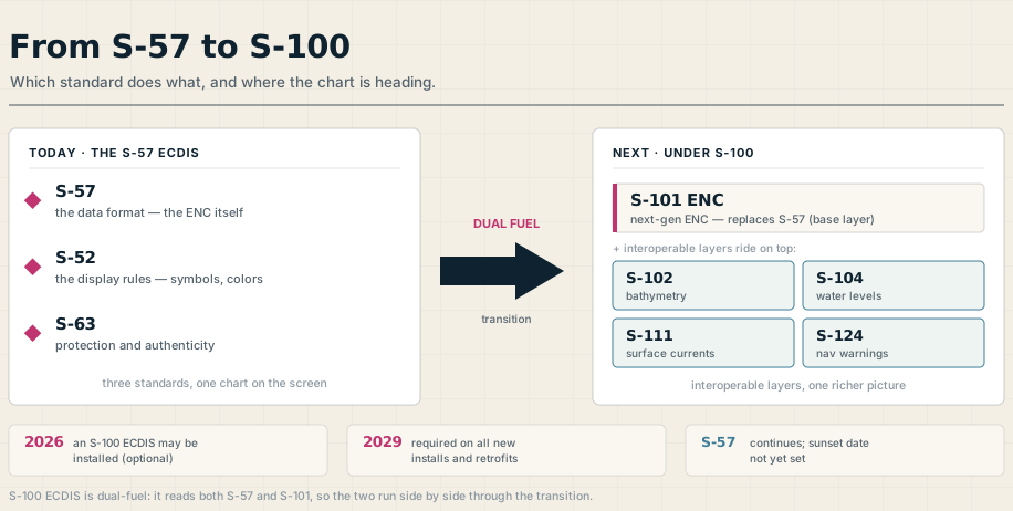
The key idea is interoperability. S-100 is not one product but a family of them, each defined by its own specification and each adding a layer of information that can be displayed together on a single screen without turning into clutter. It is also extensible, so new data products can be added as needs arise, and much of its behavior lives in machine-readable catalogues, which means an ECDIS can be updated without an engineer coming aboard to do it.
S-101: The New ENC
Within that framework, S-101 is the next-generation ENC, the product specification that replaces S-57. It is intentionally familiar: the chart symbols are largely the same, so a navigator used to today’s ENCs will recognize an S-101 chart at a glance.
The improvements are real if undramatic at first sight. S-101 allows better orientation of text so labels overlap less, encodes complex light sectors so a single pick report tells the whole story, and adds color-filled buoy and beacon symbols and a feature that highlights exactly what changed in a chart update. More importantly, S-101 is the base layer the rest of S-100 rides on: bathymetry (S-102), water levels (S-104), surface currents (S-111), and navigational warnings (S-124) can be overlaid and made to interoperate, giving a far richer view of the water than soundings and a static safety contour alone.
Dual Fuel: The Transition and Its Timeline
None of this happens overnight, and the industry has chosen a gradual path called dual fuel. An S-100 ECDIS is built to read both S-57 and S-101 ENCs, displaying them side by side, so hydrographic offices can build S-101 coverage to match today’s global S-57 coverage without ever leaving a gap.
The regulatory milestones are set by a revised IMO performance standard. From 1 January 2026, a newly installed ECDIS may meet the new standard and be S-100 capable, though the systems and their type-approval tests are only now emerging. From 1 January 2029, the new standard becomes mandatory for all new ECDIS installations, including replacements and retrofits, not just new ships.
What is deliberately not fixed is the end of S-57. There is no sunset date for it yet, both formats are to be supported for the foreseeable future, and the dual-fuel period is widely expected to run for roughly a decade. Existing S-57 ECDIS units do not have to be replaced and can keep running as they are.
What This Means on the Bridge
For a working navigator, the practical message is reassuringly calm. You will go on using S-57 ENCs for years, an S-101 chart will feel familiar when it arrives, and the type-specific competence that already matters on ECDIS will matter just as much on an S-100 system.
The payoff is worth understanding now, because it is coming: a chart that is not just a map but a base for live layers of tide, current, and bathymetry, all working together. The alphabet behind the screen is changing, and knowing what each letter does is the first step to using what comes next.
Frequently Asked Questions
These are the questions officers and cadets ask most about the IHO chart standards, from what each one does to when S-100 takes over. Here are the short answers.
What is the difference between S-57 and S-101?
S-57 is the current data format for ENCs, adopted in 1992 and frozen since 2000, while S-101 is its modern replacement under the S-100 framework. S-101 keeps the familiar chart symbols but carries richer data and, crucially, acts as the base layer that other S-100 data layers can be overlaid on. The two will run in parallel during the dual-fuel transition.
What does S-63 do?
S-63 is the IHO data protection scheme for ENCs. It encrypts the data against piracy, controls access so a ship can open only the cells it is licensed for, and authenticates the data so the mariner can be confident it is genuine and comes from an official source. In short, it is what makes an electronic chart trustworthy.
What is S-100?
S-100 is the IHO’s Universal Hydrographic Data Model, a framework rather than a single chart format. Built on modern geospatial standards, it lets many different data products, charts, bathymetry, tides, currents, warnings, be displayed and interoperate on one screen, and it is extensible so new products can be added over time.
When is S-100 mandatory?
Under the revised IMO performance standard, a new ECDIS may be S-100 capable from 1 January 2026, and from 1 January 2029 all newly installed ECDIS, including retrofits and replacements, must meet the new standard. Existing S-57 ECDIS units are not required to be replaced.
Will S-57 charts stop working?
Not for a long time. There is currently no sunset date for S-57, both formats are supported for the foreseeable future, and the dual-fuel period is expected to last around a decade. An S-100 ECDIS reads both, so S-57 and S-101 ENCs work side by side until S-101 coverage is complete.