Great Circle vs Rhumb Line: Which Route Is Shorter?
The straight line on your chart is rarely the shortest way there. Why the great circle beats the rhumb line over long distances, why it looks like a detour, and when to use each.
The straight line you draw between two ports on a chart is rarely the shortest way to sail between them. That line is the rhumb line, and it is easy to steer but longer than it needs to be. The genuinely shortest track, the great circle, looks like a detour curving away toward the pole.
Why the awkward-looking curve wins is one of the oldest puzzles in navigation, and understanding it is still worth real fuel and time on a long ocean passage.
Two Ways to Get There
There are two natural ways to join two points on the round Earth, and they answer different questions. The rhumb line answers “what single course keeps me pointed at the destination?” The great circle answers “what is the genuinely shortest distance over the curve of the planet?”
For a short hop, they are almost the same line and the choice barely matters. Over an ocean, at high latitude and running mainly east or west, they diverge sharply, and the difference becomes a decision about distance, fuel, and time.
The Rhumb Line: One Course All the Way
A rhumb line, (also called loxodrome) is the track that crosses every meridian at the same constant angle. Because the angle never changes, you steer one course from start to finish, which is exactly why it is so convenient.
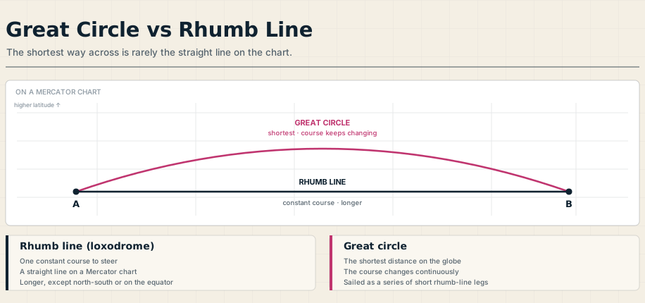
This is also why a rhumb line is a straight line on a Mercator chart. The whole purpose of the Mercator projection is to render a constant-course track as a straight line you can lay off with parallel rulers, which is what made it the navigator’s chart for centuries. The price is that, on the actual globe, a rhumb line is a slowly tightening spiral curving toward the pole, and except along a meridian or the equator it is always longer than the great circle.
The Great Circle: The Shortest Path
A great circle is any circle on the Earth’s surface whose plane passes through the center of the planet, dividing it into two equal halves. The arc of a great circle is the shortest distance between two points on a sphere, which is the whole reason it matters.
The catch is that the great-circle track crosses each meridian at a different angle, so the course changes continuously as you proceed. There are only two special cases where a great circle and a rhumb line coincide: along the equator, and along any meridian running due north and south, both of which are themselves great circles.
Why the Great Circle Looks Longer but Is Not
On a Mercator chart the great circle appears as a curve bowing toward the nearer pole, and to the eye it looks like the longer way round. The deception is the projection, not the distance. Mercator stretches the higher latitudes more and more toward the poles, so a track that climbs into those latitudes is exaggerated in length on the chart even though it is shorter on the globe.
Switch to a gnomonic chart and the picture flips. On a gnomonic projection a great circle is drawn as a straight line, while the rhumb line becomes the curve, which is precisely why gnomonic charts are used to plan ocean routes. The navigator draws the straight great-circle line on the gnomonic chart, reads off a series of positions along it, and transfers those to the Mercator chart to sail.
How Much It Saves, and When to Use Each
The saving depends entirely on where and how you are sailing. On a short passage, in low latitudes, or on a track running mainly north and south, the two routes are so close that the rhumb line’s simplicity wins outright and the great circle offers nothing worth the trouble.
The further you go, the higher the latitude, and the more the passage runs east to west, the more the great circle pays. On long crossings of the North Atlantic or the North Pacific the difference can run to scores of miles, enough to justify the continuous course changes a great circle demands. The honest rule of thumb is simple: short and low, sail the rhumb line; long, high, and east-west, sail the great circle.
Sailing a Great Circle in Practice
No one steers a course that changes by the minute, so a great circle is not sailed as one smooth curve. It is broken into a series of short legs, each a rhumb line between two waypoints lifted from the great-circle track, with a small alteration of course at every waypoint. Modern passage planning systems compute the great circle and lay out those waypoints automatically, but the principle is the same one navigators used with a gnomonic chart and a pencil.
There is one important refinement called composite great-circle sailing. A pure great circle between two high-latitude ports can carry the ship far poleward, into ice, severe weather, or restricted waters, so the navigator caps the track at a chosen limiting latitude. The ship sails a great circle up to that parallel, runs along the parallel as a rhumb line, then follows a second great circle down to the destination, trading a little distance for a great deal of safety. The choice of route, in the end, still belongs to the navigator, who must weigh distance against weather, ice, and traffic, not to the formula.
Frequently Asked Questions
These are the questions officers and cadets ask most about great circle and rhumb line sailing, from which is shorter to how it is actually steered. Here are the short answers.
Is a great circle or a rhumb line shorter?
The great circle is shorter. It is the shortest distance between two points on a sphere, while the rhumb line, which holds a constant course, is always longer except along the equator or a meridian. The difference grows with distance and latitude.
Why does a rhumb line look straight on a chart?
Because the Mercator projection is designed that way. Mercator renders a track of constant course as a straight line, so a rhumb line can be drawn and steered with parallel rulers. The trade-off is that the higher latitudes are stretched, which makes the shorter great circle look longer.
Why does the great circle curve on a Mercator chart?
Because a great circle crosses each meridian at a changing angle, and Mercator distorts that into a curve bowing toward the nearer pole. On a gnomonic chart the same great circle is a straight line, which is why gnomonic charts are used to plan great-circle routes.
How do you steer a great circle if the course keeps changing?
You sail it as a series of short rhumb-line legs. The great-circle track is divided into waypoints, and the ship steers a constant course between each pair, altering slightly at every waypoint. ECDIS and GPS compute these automatically.
What is composite great-circle sailing?
It is a great circle capped at a chosen limiting latitude to avoid carrying the ship too far poleward into ice or heavy weather. The ship sails a great circle to that parallel, runs along the parallel, then takes a second great circle to the destination, balancing the shortest distance against safety.