An electronic chart is only as safe as its last update, and the most dangerous thing about updating an ECDIS is how quiet it is. On paper, an uncorrected chart shows its age. On a screen, an out-of-date cell looks exactly like a current one, right up until it puts you somewhere the chart no longer says is safe.
Updating an ECDIS chart is genuinely easier than the old paper routine of cutting and pasting corrections by hand. But easier is not the same as automatic, and the parts the system does not do for you are precisely the parts that matter most.
At a Glance
Why Updating Is Different on ECDIS
On an ECDIS, corrections arrive as data rather than as pen-and-ink amendments, and the system applies most of them itself. That convenience changes the nature of the task: the work shifts from making the corrections to confirming they were received, applied, and complete.
The legal duty has not changed. SOLAS still requires charts to be kept up to date, and Port State Control can call up the ECDIS update listing to check that your ENCs are current. An ENC that has missed its updates is not a paperwork slip; it is a chart that may be quietly wrong about the very dangers you are relying on it to show.
How an ENC Update Actually Works
Updates flow on a weekly rhythm. Hydrographic offices and the regional centers that coordinate them issue Notices to Mariners every week, and those corrections are packaged for delivery to ships.
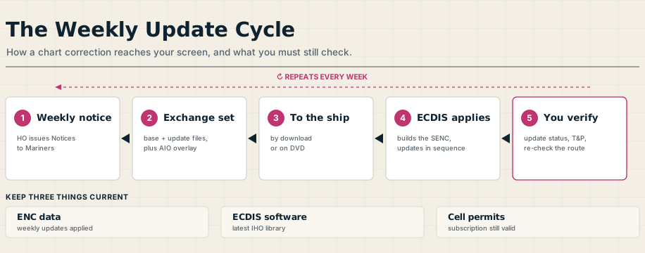
The data arrives as an exchange set: a base cell, which is the full edition of a chart, plus a series of small update files that must be applied in sequence on top of the matching base. When you load them, the ECDIS converts the ENCs into its own internal format, the System ENC or SENC, and applies the updates to build the current picture. If a cell in use has not been brought up to date, or an update fails to apply, a properly working ECDIS will warn you rather than stay silent.
One thing to watch is the difference between an update and a New Edition. Routine updates layer onto the existing base, but a New Edition replaces the base cell entirely, so the older updates no longer apply and the new base has to be loaded fresh.
Getting the Updates Aboard
The corrections reach the ship in one of two ways: by download, over the internet through a file-share service or by email, or on physical media such as a weekly DVD. Most fleets use an official service like the Admiralty Vector Chart Service, which supplies the weekly updates and bundles tools to manage chart holdings.
There is a commercial layer beneath all this that has navigational consequences. ENCs are licensed by subscription, cell by cell, for fixed periods, and the ECDIS will only load the cells your permits cover. Let a subscription lapse and those cells stop updating, so keeping the licence current is part of keeping the chart current, not a separate billing matter.
The T&P Trap: When Updates Do Not Tell the Whole Story
Here is the part that catches people out. Temporary and preliminary notices, the short-lived warnings about works, wrecks, and changed buoyage, are not handled the same way by every hydrographic office. Some encode them straight into the ENC, where they appear as normal chart objects that your route check will assess automatically, and others do not include them at all.
To cover the gap, services like the Admiralty Information Overlay carry temporary and preliminary notices, and ENC preliminary notices, as a separate layer drawn over the ENC, free with the subscription and updated weekly. It is a genuine safeguard, but not an infallible one: the overlay can lag behind the source notices, so it should be checked against the weekly Notices to Mariners rather than trusted blindly.
Where neither the ENC nor the overlay carries a notice, the correction becomes your job. The navigator applies it as a manual update, keeps a written log of every manual correction held, and removes each one when the notice is withdrawn. Navigational warnings broadcast by Navtex or satellite are more urgent still, and these are plotted by hand the moment they arrive.
After the Update: Re-Check the Route
Applying the updates is not the end of the job, because a correction can change the water you planned to cross. A New Edition or a fresh notice can add a traffic separation scheme, a reporting line, or an isolated danger directly onto your intended track.
So once the charts are current, the plan has to be re-examined against them. Run the route check again so any newly added danger is caught, revise the passage plan where needed, and make sure every ECDIS on the bridge has received the same updates, since a second unit running on older data is a trap waiting for the moment you switch to it.
Three Things to Keep Current
Step back from the detail and chart currency comes down to three things kept in step. The ENC data must carry its weekly updates, the ECDIS software must be maintained to the latest IHO standards so it displays the data correctly and sounds the right alarms, and the cell permits must stay valid so the updates keep flowing.
Miss any one of the three and the chart in front of you is no longer fully trustworthy, however confident it looks. Updating an ECDIS is quick, but it is never finished, and treating it as a standing weekly discipline rather than a one-time task is what keeps the picture on the screen honest.
Frequently Asked Questions
These are the questions officers and cadets ask most about ECDIS chart updating, from how often it happens to what the system will not do for you. Here are the short answers.
How often are ENCs updated?
ENCs are updated weekly. Hydrographic offices and the regional centers that coordinate them issue Notices to Mariners every week, delivered to ships by download or on DVD, and applied to the ECDIS to keep the charts current and SOLAS-compliant.
What is the difference between a base cell and an update file?
A base cell is the full edition of an ENC, while update files are the small weekly corrections applied on top of it. They must be applied in sequence to the matching base, and the ECDIS converts the result into its internal format, the SENC. A New Edition replaces the base entirely, so the new base must be loaded fresh.
Does ECDIS apply chart updates automatically?
Largely, but not entirely. The ECDIS applies the received update files itself and warns you if a cell in use is not current or an update has failed. What it does not do automatically is handle every temporary notice, apply manual corrections, or re-check your passage plan, which remain the navigator’s responsibility.
What are T&P notices on ECDIS?
Temporary and preliminary notices cover short-lived dangers such as works, wrecks, and changed buoyage. Some hydrographic offices encode them into the ENC, others do not, so an overlay such as the Admiralty Information Overlay carries the missing ones as a separate layer. Anything not covered must be applied as a manual update.
What do you do after updating ENCs?
Re-check the route. A New Edition or notice can add a new traffic scheme, reporting line, or isolated danger onto your track, so the route check should be run again, the passage plan revised where needed, and every ECDIS on the bridge confirmed to hold the same updates.